Why it's so important to be ready for anything when planning and executing a maritime voyage
One of the most fundamental principles of good seafaring is that planning before a journey is of paramount importance. The recommended best-practice approach to voyage planning comprises four stages: appraisal, planning, execution and monitoring. These stages necessarily take into consideration every aspect of ensuring a route is safe, timely and compliant with all laws and regulations in effect. Factors to consider include close scrutiny of charts, tide tables, Admiralty Sailing Directions, weather forecasts as well as all relevant publications and notices. Every potential safety impeding variable should be taken in account and every effort made to mitigate environmental hazards.
The guiding principle is to ensure that while at sea, little is left to chance. However, even the most prudent planners will operate on the assumption that, even with painstaking diligence, a worst-case scenario might still occur at some point and must therefore be planned for. Despite comprehensive planning, the fast-paced nature of the maritime industry means voyage plans are routinely updated on the fly. Experienced mariners know this and will accordingly devise fallback measures to deal with such eventualities.

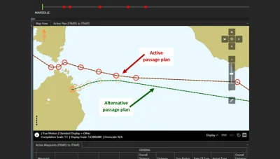
Contingency planning is among the most profoundly important safety elements of any voyage. It entails devising several alternative routes if, for any reason, the vessel’s designated route cannot be followed. Perhaps there is a medical emergency aboard, a large disruption at a destination port, adverse weather along a planned route, or simple a change of plans.
Masters and crews are already accustomed to working out an optimal route based upon the most pressing criteria, whether these are related to expenditure, time, fuel consumption or a combination of all. These same factors are applicable when scoping out alternative routes. Shore teams and bridge crews will still need to consult weather forecasts and determine marine environmental restrictions. They still need to verify safety depths and assess whether any NavArea warnings, ECA zones, Vessel Traffic Schemes or no-go areas are likely to affect the passage. An alternative route is of no use if it exposes the crew, their vessel and the cargo to potential hazards, or if it is so protracted as to render the transit unprofitable.
Safe anchorages
Other factors to include in contingency planning are appraisals of alternative safe anchorages and waiting areas in the event of berth or cargo unavailability, weather or paperwork delays or amendments to the voyage plan. The prerequisites here are to identify safe anchorages which will take weather conditions, sea state, water depth and direction of current into consideration; which will also provide an adequate shoreline depth and a secure holding ground; and which lie within the relevant Port State Authority’s territorial waters. The combination of these considerations will effectively guarantee that the vessel won’t run aground, create environmental damage or risk colliding with other ships.
Similarly, contingency plans need to include provisions for emergency anchoring and confirming the whereabouts of ports of shelter or places of refuge. Planning emergency anchoring procedures is a very literal definition of preparedness: ensuring that, for example, both anchors are held on the brake, ready to be deployed simultaneously in tandem with instructions to shut off or reverse the engines, to halt the vessel as rapidly as possible in serious situations.
Contingency plans also need to be made in case urgent action is required to assist a stricken vessel, all the while minimising risk to crew, the environment and other ships. These plans will need to take into account the fact that access to ports of shelter depends on numerous strict criteria which can vary from vessel to vessel and area to area, so a familiarity with the relevant provisions of the VTMIS (Vessel Traffic Monitoring & Information Systems) Directive is strongly recommended.
E-Navigation
Patently, accumulating all the data required for contingency planning is not a task to be taken lightly. Undertaking the job manually will eat up a colossal amount of time and expend a great deal of energy in terms of chasing up port authorities, consulting charts and relevant publications, monitoring weather alerts and so on. The protracted, scattershot nature of conducting these processes manually also introduces the very real probability of human error occurring somewhere along the line, with potentially serious results. The logical answer is therefore to put e-navigation solutions to work.
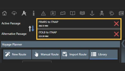
The OneOcean platform is a prime example of a digital solution that gives crews the functionality needed for comprehensive voyage planning, which necessarily includes contingency planning. All digital chart and publication data is accessible through the platform, as well as an entire suite of navigation, safety, regulatory compliance, reporting and fleet management solutions. Users have a rich source of vital information needed to plan safe, cost-effective, compliant and timely voyages.


OneOcean also stores historical data on past voyages, a fact that will also, of course, allow crews to learn from previous voyages. This is an invaluable aid to contingency planning as information will help to clarify areas where there is room for improvement in terms of safety, cost-effectiveness and environmental responsibility.
To find out more about how your organisation can benefit from a comprehensive passage planning solution that reduces risk, contact the OneOcean team.

